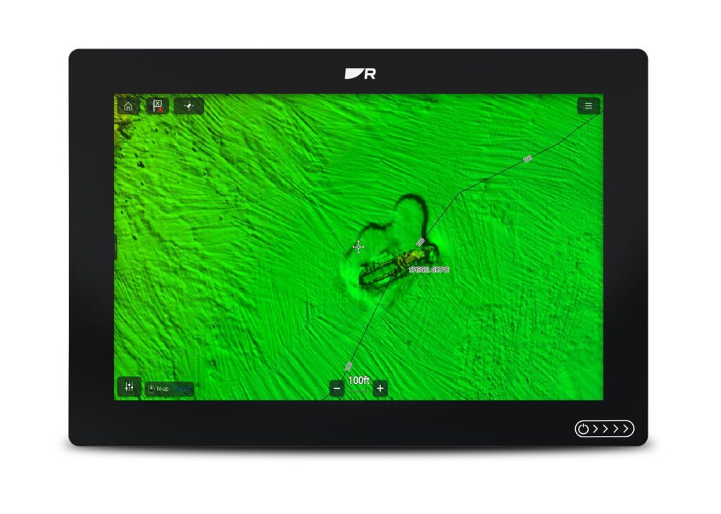
Raymarine announced recently that the new CMOR NEX GEN all-in-one seafloor and navigational charts are now compatible with all Raymarine Axiom 2 chart plotters. South and West Florida regions will be available first, with the full 13-region catalog rolled out soon.
CMOR NEX GEN offers more than traditional mapping by combining ultra-high resolution bathymetric imagery with full navigational data and satellite imagery. Key features include:
• Ultra-High-Resolution Bathymetry
Detailed seafloor imagery revealing subtle ledges, wrecks, rockpiles, humps and drop-offs with unparallelled clarity.
• Integrated Navigational Icons and Aids
Seamlessly overlays beacons, buoys and other standard navigation symbology – so users don’t lose reference to critical safe passage markers.
• Recommended Routes and Course Planning
Preloaded preferred navigation with suggested approaches to harbors, safe entry/exit channels and optional routing aids based on depth, hazards, and vessel type.
•Named Wrecks, Reefs & Submerged Features
Annotated seafloor features with labels – sunken vessels, reef names, rock formations – making it easier to plan drops or dives at recognized structure.
•Bridge, Marina and Infrastructure Data
Details on bridges such as clearances, timings, spans and marina layouts with slips, fuel, services.
•Satellite/Aerial Imagery Layer
True-to-life surface imagery of coastlines, islands, mangroves, docks, land use providing visual context at a glance. Users can identify shoreline features visually, compare land vs. water and better orient themselves.
•Smart Layering and Zoom-Adaptive Display
Dynamic switching or blending of layers as the display is zoomed in or out with full satellite imagery and bathymetry at close range and simplified base map further out to preserve clarity and performance.
“At Raymarine, we understand boaters have a wide variety of favorites when it comes to the ‘flavor’ of mapping they prefer – whether they’re serious anglers, sailors or daytime cruisers,” said Jamie Dery, Vice President of Raymarine Americas. “CMOR NEX GEN is not just simply a map, it offers the complete marine view from deep water to shorelines. This integration is sure to give our customers a new level of confidence while navigating and exploring new locations across the seas.”
Learn more at raymarine.com.